|
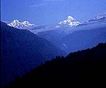
Kumaon and Garhwal is the mountainous area in the northern Uttar Pradesh. There are more than 100
peaks over 20,000 Ft in Kumaon and Garhwal. . Anybody visiting these blessed lands is enchanted by
their stunning beauty and is sure to return again and again.
 To the North lie the Zanskar and Greater Himalayan ranges. Across the ranges lies Tibet in the North
and Nepal in the South-East. The trekking around Nanda Devi has always been the most popular and
was explored by numerous trekkers who include Shipto, Tillman, Frank Smythe and Lord Curzon. To the North lie the Zanskar and Greater Himalayan ranges. Across the ranges lies Tibet in the North
and Nepal in the South-East. The trekking around Nanda Devi has always been the most popular and
was explored by numerous trekkers who include Shipto, Tillman, Frank Smythe and Lord Curzon.
The Land is home to numerous holy shrines which are visited by millions in the summer, pilgrims who
risk to venture along the treachorous trails and reach the Abode of The God’s.
Best Trekking Period :April to June & Sep/Oct. |
The following are "no-frills" trekking trips of reasonable standard
and prices. For more information, please click on the trips' title or email me.
Prices will be listed later on.
* Difficulty Grading : 1 to 4 grades where 1 is relatively
easy walking,and should not exceed 5 to 6 hours per day, 2 for trips with longer
hours of 6 to 7 hours daily and some hill-walking, 3 for trips that are moderate with
trekking above 4,500 metres and 4 for strenuous trips with daily
walking estimated at 7 to 9 hours and trekking about 5000 metres.

HAR KI DUN AND RUINSARA LAKE
This is one of the easier and most popular treks in the Garhwal Himalayas. Numerous options are
available to extend this trek over high passes into Himachal Pradesh or other valleys in Garhwal. This
trek along the Tons River valley is surrounded by high mountains and dense forests. For bird watchers
this trek is highly recommended in the pre Monsoon months and the post Monsoon season is ideal for
appreciating wild flowers. Ruinsara Lake is nestled under the Swargrohini Range and the area is
associated with Hindu mythology.
Maximum Altitude : 3510 mts, Har ki Dun
Trekking Period :April to November.
ITINERARY
DAY 01: New Dehi-Rishikesh (250 kms, 6-7 hrs)
Drive from Delhi to Rishikesh. Spend the night at our rafting camp and meet your trekking guide.
DAY 02: Rishikesh-Sankri (210 kms, 6-7 hrs)
Drive to Sankri (1450 mts), the starting point of the trek. Dinner and overnight at the Tourist Rest
House.
DAY 03: Sankri-Taluka. (3-4 hrs)
The trail is well forested with chestnuts, bamboo and sycamore. There is a lot of
opportunity for bird watchers along this trail. Taluka (1800 mts) is a small village with not much to offer, so we camp just
before the village.
DAY 04: Taluka-Seema (5-6 hrs)
Trek along the Tons Valley passing through few traditional Garhwali Villages. Seema (2500 mts) has the
option of accomodation in a Rest house if available.
DAY 05: Seema-Har ki Dun (4-5 hrs)
Trek along the true right of the river through pine forests and meadows. Har ki Dun (3510 mts) has a
few small valleys around worth exploring.
DAY 06: Har ki Dun-Dev Thach (3-4 hrs)
Trek and camp on a beatiful meadow just above Dev Thach (3000 mts).
DAY 07: Dev Thach-Ruinsara Lake (4 hrs)
Trek through along a brilliant alpine trail to reach the holy Ruinsara Lake (3350mts). The views of the
Swargrohini Range are particularly impressive from here. There are a few options to extend the trek from
here and continue to the Yamuna or Bhagirathi Valleys.
DAY 08: Ruinsara Lake-Dev Thach (3-4 hrs)
Trek back to Dev Thach while appreciating wild flowers and birds along the trail.
DAY 09: Dev Thach-Datmir (4-5 hrs)
Easy trekking till the next camp just short of the village of Datmir.
DAY 10: Datmir-Sankri (3-4 hrs)
Trek on the left bank of the River Tons till Sankri where the trek finishes. Last night in camp or Tourist
Rest House.
DAY 11: Sankri-Rishikesh (6-7 hrs)
Drive to Rishikesh and spend the night in a good hotel.
DAY 12: Rishikesh-Delhi (6-7 hrs)
After breakfast drive back to Delhi.
Back to Top
SHIPTON TILLMAN ROUTE
The Mountains in Garhwal were explored extensively by the legendary 'Terrible Twins', Shipton and
Tilman. This trek in the Garhwal Himalayas and around Nanda Devi is dedicated to them. This fabulous
itinerary is a combination of the famous Curzon's Trail trek along with trekking to the mysterious Rup
Kund Lake and the famed Valley of Flowers. Dazzling arrays of peaks are part of the scenery on this
trek. The Nanda Devi (7816 Mts.)and Trishul Massifs (7120 Mts.) loom over the trail. The other big
peaks around are Nanda Ghunti (6309 Mts.) and Kamet (7758 Mts.). The trail over the Kauri Pass is
called Curzon's trail because of the affection Lord Curzon had for this trek.
Maximum Altitude : 4258 Mts. at the top of the Kauri Pass.
Trekking Period : April to November.
ITINERARY
DAY 01: New Delhi-Rishikesh
The options are to travel by bus or train till Haridwar and then taxi to Rishikesh. Meet your guide
today.
DAY 02: Rishikesh-Mundoli (8 hrs)
Drive from Rishikesh to Mundoli (1970 Mts.). This is the starting point of the trek. Overnight at the
Tourist Rest House or in tents.
DAY 03: Mundoli-Bedni Bugyal (5-6 hrs)
Bugiyal means Meadow in the Garhwali language. The meadows are just below the Trishul Massif and
the views of other big peaks of Garhwal are also breathtaking. The altitude is 3350 Mts.
DAY 04: Bedni Bugyal-Bhogubasa (4-5 hrs)
The trail ascends gently at first and there are few steep ascents later in the day. Bhogubasa (4100 Mts.)
is a high altitude camp. The weather and terrain are strikingly different to Bedni Bugyal. The views of
Trishul are uninterrupted.
DAY 05: Bhogubasa-Rup Kund-Bhogubasa (7-8 hrs)
The trek up to Rup Kund (4450 Mts.) is hard but rewarding. The lake has many myths attached to it. The
human bones in the small lake date back many centuries.
DAY 06: Bhogubasa-Wan (3-4 hrs)
Gentle trekking to get to Village of Wan (2450 Mts.).
DAY 07: Wan-Sutol (4-5 hrs)
Trek to Sutol (2200 Mts.) via the Village of Kunol. Pass through a beautiful well-forested trail.
DAY 08: Sutol-Dekhandar (4-5 hrs)
Easy trekking on this day. The trail keeps ascending and descending
DAY 09: Dekhandar-Ramni (3-4 hrs)
Trek along the Nandakini River to Ramni Village(2550 Mts.). The trail passes some quaint Garhwali
houses.
DAY 10: RAMNI-JHI JHI.
A short 4 Km steep climb upto Sarkot (2349 Mts.) and than an easy 9 Km walk from Sarkot to
Jhenjipatni (2100 Mts.).
DAY 11: JHI JHI-PANARANI
A steep descent from the camp through forests brings you to a spectacular suspension bridge at 1840
Mts. slung across the Birehi Gorge. After an hours ascent you are back at 2250 Mts. and the trek eases.
After going around the horseshoe valley you reach a lonely river in about four hours time from
Jhenjipatni. From here it is a short climb to the camp at Kaliaghat, which is half a kilometer from
Panarani.
DAY 12: PANARANI-DOMABHITI
A 10-Km trek that takes us through forests and meadows. Campsite (2286 Mts.) is located near the
stream, and we camp here. From here we can see the Kuari pass.
DAY 13: DOMABHITI-KUARI PASS-WODAR
Early morning we start our 4-Km strenuous climb to Kuari Pass (4258 Mts.). The peaks visible from the
pass are Nandadevi, Dunagiri, Bethartoli, Devsthan etc. After crossing the pass we camp at Wodar.
DAY 14: WODAR
From this camp you can spend the day exploring the surroundings. The campsite is set in the meadows
surrounded by pine trees.
DAY 15: WODAR-TAPOVAN-JOSHIMATH
After breakfast we trek upto Tapovan (1714 Mts.)covering 12-kms in 4-5 hours. The route is gentle
walking. At Tapovan we meet our transport. Drive to Joshimath (1871mts) located 15 km. Dinner and
overnight in Hotel.
DAY 16:JOSHIMATH- GOVINDGHAT - GHANGRIYA
After breakfast drive to Govindghat (1828 m) covering approx. 12 kms, situated at the confluence of
Alaknanda and Lakshman Ganga rivers. Upon arrival trek to Ghangriya (3500 m). The distance of 14 km
is covered in about 5 hrs. The trek begins by crossing the suspension bridge over the Alaknanda River.
One can have panoramic views of Kak Bhusandi Valley. Ghangriya is the base for both Valley of
Flowers and Hemkund Sahib, which is the holiest place for the Sikhs.
DAY 17: GHANGRIYA - HEMKUND - GHANGRIYA
After breakfast trek 5 km to Hemkund Sahib (4329 m). The winding path climbs upto a high altitude
Himalayan freshwater lake with a profusion of flowers. Legend has it that this lake was made by Lord
Rama's brother, Laxman, by shooting an arrow to quench the thirst of Sita. There is a temple dedicated
to Laxman and a Gurudwara. A stream flows out of the lake and joins the river Alaknanda near Govind
Ghat. Return to Ghangriya for dinner and overnight stay in tents.
DAY 18: GHANGRIYA - VALLEY OF FLOWERS - GHANGRIYA
Ghangriya is nestled amidst the giant Deodars. After breakfast trek to the Valley of Flowers. The path
climbs up steadily. The Valley is spread in approximately 20 sq. kms. area. It was discovered
accidentally by the British mountaineer, Frank Smythe, while returning from Mount Kamet in 1934 in the
upper reaches of Bhyunder Valley. The elevation ranges between 3352 to 3658 m. It has the largest
collection of wild flowers. Notable among them are Himalayan Blue Poppy, Braham Kamal,
Rennanclus, Jareneyum, Potentila, Dumex, etc. Return to Ghangariya for dinner and overnight stay in tents.
DAY 19: GHANGARIYA - GOVINDGHAT - BADRINATH
After breakfast trek to Govindghat and drive to Badrinath ( 3100 m ) located 24 kms. Badrinath lies on
the banks of the Alaknanda and is devoted to Lord Vishnu. Legend has it that Badrinath was the home
of Lord Shiva. It was only much later when Lord Vishnu ,in his incarnation as Narayan, made this valley
his abode. Dinner and overnight in hotel.
DAY 20: BADRINATH- KARANPRYAG
After breakfast drive for 111 kms in 5-6 hours. Karanpryag located at the confluence of the Pindar and
Alaknanda rivers. Worth seeing here are the temples of Uma and Karn. Overnight stay in Tourist
Bungalow/Rest House.
DAY 21: KARANPRYAG-RISHIKESH.
Drive along the river Alaknanda to Shivpuri in approximate 08 hours covering 186 kms approx. Dinner
and overnight in hotel.
DAY 22: Rishikesh- New Delhi
Catch road transport or train back to Delhi.
Back To Top
KALINDI KHAL TREK
This is for the most adventurous trekkers who have a fundamantal knowledge of the mountains and
trekking. The trek is over the Kalindi Khal (pass) at the awesome altitude of 5947 mts. This trail
connects the two holy shrines of Gangotri and Badrinath and passes through the remotest parts of the
Garhwal Himalayas.
Maximum Altitude :5947 mts, Kalindi Khal Pass.
PERMITS : Permits from the Govt. of India are necessary and will be arranged.
SPECIAL EQUIPMENT:
Personal trekking equipment fit for high altitudes.
Crampons and safety equipment will be ours, though you can carry your own crampons etc.
ITINERARY
DAY 01: New Delhi-Rishikesh (6-7 hrs)
Travel from Delhi to Rishikesh by coach or train.
DAY 02: Rishikesh-Uttarkashi (8 hrs)
Drive to Uttarkashi along the Ganges River. Overnight at Dak Bungalow or tents.
DAY 03: Uttarkashi-Gangotri (7-8 hrs)
Drive to Gangotri (3050 mts) along the Bhagirathi River. Overnight in tents.
DAY 04: Gangotri-Bhojbasa (6-7 hrs)
Walk along a gradual, well laid, pony trail to Bhojbasa (3792 mts). First great views of the Bhagirathi
Massif and Shivling Mountain. 2kms beyond Bhojbasa is the camp site.
DAY 05: Bhojbasa-Nandanvan (5-6 hrs)
Hard walking up to Gaumukh and then traverse the glacier to get to the beautiful meadows of
Nandanvan(4340 mts).
DAY 06: Nandanvan-Vasukital (6-7 hrs)
Walk along a pleasant meadow with views of Mts Meru and Brighupant including many others. Pass a
deep gorge and reach Vasuki Tal (lake). Camp on the north west ridge of Vasuki Parvat (4950 mts)
DAY 07: Vasuki Tal-Surayala Bamak
Traverse the slopes of Vasuki Parvat (mountain) and pass the Sundar Valley to get a sudden view of
Mt Satopanth. Trek over an easy glacier and a steep rocky slope to get to our next camp at 5200 mts.
DAY 08: RESERVE/REST DAY
Extra day to rest or for bad weather.
DAY 09: Suryala Bamak-Seta Bamak
Steep and tough trek across Suryala Glacier. Trek to the lateral moraine of the Kalindi Glacier and camp
below Avalanche Peak.
DAY 10: Seta Bamak-Kalindikhal Base
Set off along the Kalindi Glacier carefully avoiding the open crevasses. After sometime we approach a
steep crevasses slope which leads to the Kalindi Khal (pass). Camp at the base of Kalindi
Khal. (5400 mts).
DAY 11: Kalindi Khal
Climb a steep crevassed slope leading to the Kalindi Khal and descend close to Avalanche Peak. The
route is crevasses and all care has to be taken.
DAY 12: RESERVE/REST DAY
For bad weather.
DAY 13: Rest camp-Gastoli (9-10 hrs)
Pass Arva Tal (lake) and trek to the end of the Arva Valley where the Arwa river meets the Sraswati
River. Reach Ghastoli Village and camp.
DAY 14: Ghastoli-Mana Village (4-5 hrs)
Trek down a good pony trail and reach Mana Village. The river Saraswati is said to go underground
here and reemerge at Allhabad to meet the Ganges and Yamuna Rivers.
DAY 15: Mana-Badrinath
Trek to Badrinath and visit the holy shrine. Last night in Camp.
DAY 16:Badrinath-Joshimath
Drive to Joshimath Town. Overnight in hotel.
DAY 17: Joshimath-Rishikesh
Drive to rishikesh and spend the night at our Rafting camp.
DAY 18: Rishikesh-Delhi (250 kms, 6-7 hrs)
Drive back to Delhi.
Back to Top
Pindari Glacier Trek
The trek begins from Bageshwar which is an important Hindu pilgrimage center. The Pindari Glacier is
about 3 kilometers long and is fed by the South-Western slope of the Outer wall of the Nanda Devi
Sanctuary.
Maximum Altitude :3260 Mts at Phukria.
Trekking Period :
April to November.
ITINERARY
DAY 01: New Delhi-Bageshwar
Long overnight drive of 470 Kilometers to reach Bageshwar . Overnight at the Tourist Rest House.
DAY 02: Bageshwar-Loharkhet
45 Kms drive followed by a 3 Km trek to reach your first camp.
DAY 03: Loharkhet-Khati (5-6 hrs)
Bugiyal means Meadow in the Garhwali language. The meadows are just below the Trishul Massif and
the views of other big peaks of Garhwal are also breathtaking. The altitude is 3350 Mts.
DAY 04: Khati-Phukria (6 hrs)
Cross the treeline to the pasteurs at Phukria (3260 Mts).
DAY 05: Phukria-Zero point-Dwali (4 hrs)
Zero point is at a vantage and gives the best views of the glacier and the mighty mountains.
DAY 06: Dwali-Dhakuri (6 hrs)
Great views of Nandakot (6806 Mts) and beautiful trek along the ridge.
DAY 07: Dhakuri-Bageshwar
Trek till Song and then board land transport for a 40 Km drive back to Bageshwar.
DAY 08: Bageshwar0Delhi
Leave for Delhi after and early breakfast.
Back to Top